Tuesday, April 5, 2016

Off to Fort Myers......

except.......we woke up to fog again.

But, we're in no hurry, really.  It's only about 15 miles to Fort Myers from the Franklin Lock, so we kicked back and waited.  Had a nice breakfast and watched other boats drive off into the fog.  They were all heading east into the country.  We were heading to the city.  Downtown.  We waited.

Shortly after ten we departed and locked through.  It still amazes me that they run these big locks to let one little boat through, but they do.  It was an easy trip into Fort Myers.  Uneventful except for a long, narrow channel through a no wake manatee zone where we seemed to be the only boat not making a wake.  The motor yachts with twin turbo mega motors did their best to push us out of the channel, but not today.  I'm not sure where all the "Rigid Enforcement" of the manatee zone was but, survive it we did, and without running aground either!

We got into Fort Myers just before noon, and stopped for fuel at the Fort Myers Yacht basin.  I only add this in because I know all my sailing friends will be jealous!  Didn't need much fuel, but I realized I forgot to treat the fuel we bought in Stuart.  It couldn't have been because we just touched bottom and I could see the happy hour sign from the fuel dock, but who knows.   Maybe I'm just not a good boater.

The Fort Myers yacht basin was just upriver from our destination, and when I called them on the radio they asked us to wait as we were fourth in line for docking.  Only noon and it was quitting time already.  Now that's boating.  But they got us into our slip just before one - a real nice one in the suburbs (a far corner of the marina) right on the seawall overlooking the river where we have a great view of the river and sunsets.  We'll deal with it, I guess.

Anyway, we're a gonna be hanging out in Fort Myers for awhile.  Not sure when or where we're gonna go from here, but y'all will be the first to know,  I promise.  And I'll be sure to post some really nauseating sunset pictures for we all wait too!

Monday, April 4, 2016

Westbound......

Up before the sun....grrrrr.......

Decided to leave Clewiston at first light....with any luck, today's journey would include the Moore Haven lock,  the Moore Haven RR bridge (hopefully not, as it's usually open), the Ortona Lock, the SR 29 bridge, the Fort Denaud swing bridge, the Alva Bridge, the Franklin Lock and the Wilson Pigott bridge.  If, that is, luck was with us.  The Ortona Lock is currently under construction/revitalization and the posted hours of operation (usually 0700 to 1700) were currently 0700-0730, 1130-1230, and 1630 -1730.

The plan was to leave at first light, hopefully make the 3.5 hour trip (3.5 hours boating, not including waiting for locks and bridges) to be at the Ortona lock before the 1330 closing.  If we missed that opening, the 1630 opening would make it too late for us to make it to Fort Myers today.  Let's see what happened, shall we?

So we were up in darkness to be ready to leave at first light.  First problem of the day?  First light revealed fog.  Not the good kind.  So we sat and waited.  Without fog we could have left a little after 7.  Now, we waited.

Another Grand Banks had pulled in last evening - the NinaMia.  A 50 footer.  Real nice one too.  We had talked to them a bit last evening, we were both heading the same way, and so we agreed to travel together.  Just one problem this morning - they wanted to leave at 0730, fog and all.  Ed and Karen don't boat in fog, so they left without us.

By 0800 the weather looked better so we cut the dock lines and moved.  We were going to be in the ditch and really couldn't get lost, I just hoped to not hit anything I couldn't see.  Important safety tip.  Visibility was pretty good, actually, just some patches of fog.  So, I hit the gas (diesel) and ran faster than normal to try and catch up to NinaMia.  The problem with them being so far ahead of us was that they would get to the lock and lock through, leaving us to wait for a lock to fill and unfill.  That would definitely slow us down.  We ran into a few fog patches and I made sure the radar worked.  Didn't hit anything, so it must have.

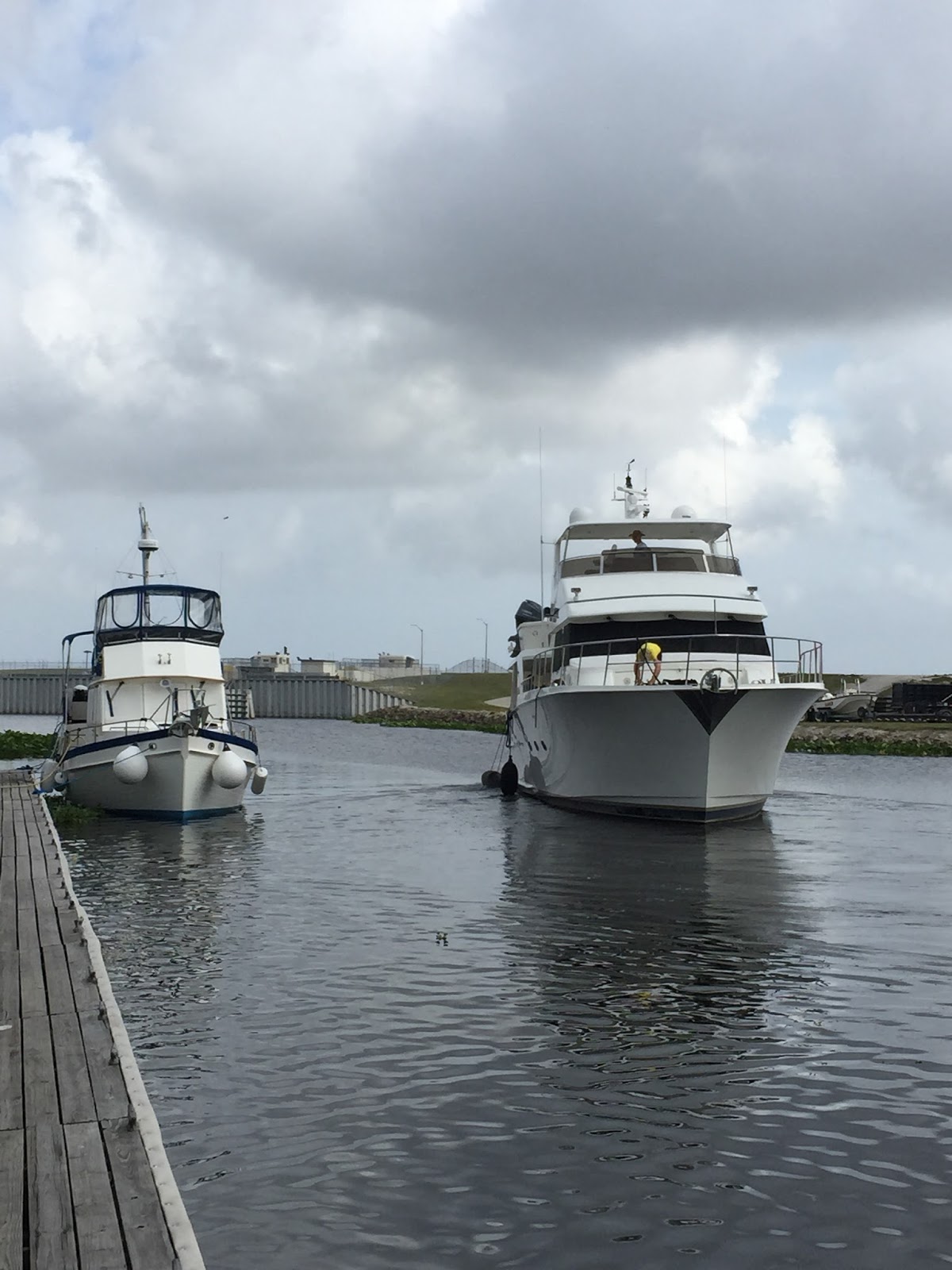
I heard NinaMia call the Moore Haven Lock and ask to lock through.  No way were we gonna make it.  But, as luck would have it, NinaMia had to wait.  And the lock opened just as we arrived.  Good day for us.  Busy day at the lock though; four boats exited, four boats went in.  NinaMia was faster than us, and broke traffic for us all day.  Bridges and locks they had to wait for we went right through.  Nice.

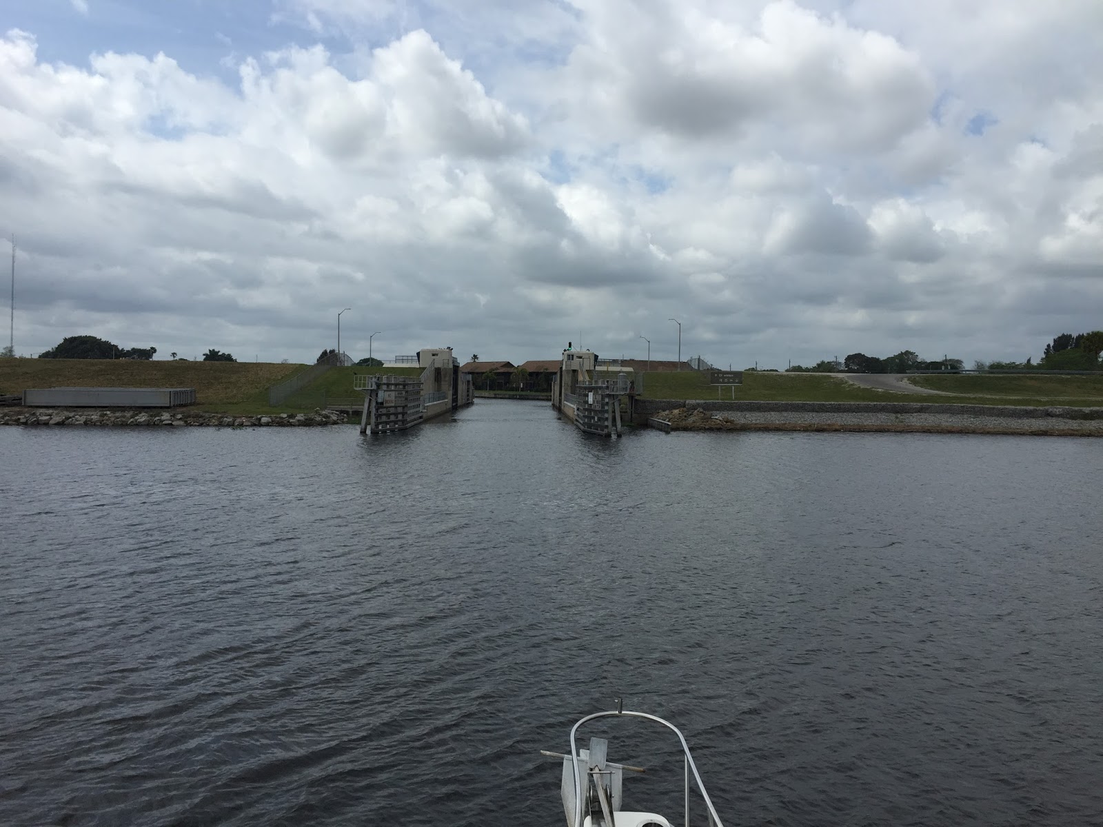
We got to the Ortona lock and miracle of miracles!  No construction today.  They locked us right through at 1100.  Way ahead of schedule.  Should be no problemo to get to Fort Myers today.

Unless.....

As we were approaching the Franklin Lock we noticed thunderheads building in the west.  Not for this guy, says I.  The Locks are run by the Army Corp of Engineers.  Many have campgrounds run by the Corp at the locks.  The Franklin lock actually runs a Boat Campground.  Eight slips with water and power for 30 bucks!  In we went and done for the day at 1430.  Not a bad day, and should be an easy jaunt into Fort Myers tomorrow.  We'll see.  Tomorrow.


Time to see if the radar really works.


The ditch is easy.  If you can see the trees growing in it......


Busy day at the Moore Haven Lock.......


Ooops.....ran aground. According to the GPS.   At 9 kts.  In 19.7 feet of water.  Very reassuring.....


James Bond was out fishing.......


Boat Campground, Franklin Lock.


Bet this guy doesn't get up every morning and check to see if he's sinking.

Sunday, April 3, 2016

Bass fishin'.....

Lake Okeechobee is apparently famous for bass fishing, as we found ourselves immersed in some real (reel?) down home Americana......a bass fishing tournament.  I've never seen so much money invested in fishing boats and fishing poles!  (Well, except for Hawaii.  And Ory Gone.  And every other deep sea fishing place I've been, but, I digress.)

To many to count bass fishing boats on the lake, and when we got into the marina there was a judging booth set up with 105 boats entered in the fishing tournament.  Judging started at 3, and at 250 a solid lineup of boats started coming in.  A sight to behold.  I don't think you've really seen 'Merica until you've been to a bass fishing tournament.  But that's just me.

Spent the day prepping to leave tomorrow.  Not sure how far we're gonna get due to construction and closures at the Ortuna Lock, so, if you wanna know how far we go tomorrow you better check back then!


Cosmic Mariner safely at the docks....Protected by pelicans.....


Never seen so many bass boats in all my born days!


Kids, remember:  always chew your food!


Fishing tournament judging booth.  All we need is fish.


Judging starts in five minutes, and here they come!


Reel (real) serious business here.


Champeens of the world!  Or at least of Lake Okeechobee today.


I thought it was a big crowd, but it was my first fishing tournament.


Fish back in the boat and back to the lake.  This is a catch and release tournament.  Note the fire rescue boat on standby.


Because it was catch and release, we had to have some boring smoked salmon sushi.


Then this big bully of a boat came up and splashed lake water on our boat.  I wonder if Charles Atlas sells exercise equipment for boats?

Saturday, April 2, 2016

Lake Okeechobee......

up at the crack of dawn with the gators....the real ones, not the football ones......

Left Indiantown marina with the sun (gee I hate that!) but we wanted to get across Lake Okeechobee early.  Weather called for thunderstorms after noon......1200.....at three hours across the lake that forced an early departure if we wanted to cross today.....Indiantown Marina was cheap and a safe place to spend the night but for long term comfort it wasn't in the cards.

Back in the ditch and off to the lake.  To enter the lake you have to pass through the Port Mayaca Lock.  Just before the lock as you head west there is a railroad bridge.  It is stored in the up position and to cross (if you're a train) the train has to come to a stop and the train crew has to manually lower the bridge.  After looking both ways, of course.  Through with no problemo, we called the Mayaca Lock.  I knew the water levels were up in the lake, but I didn't expect the lock to be left open.  It was.  Just go on through, said the lockmaster.  We did, and entered lake Okeechobee at 0915.

Lake Okeechobee is the second largest lake in the United States by size.  Only one of the great lakes is totally within the boundaries of the USA.  The others are shared with Canada.  Even though it's a large body of water, they forgot to put much water in the water.   Our journey was twenty five miles across.  The first half was wide and open without much dangerous stuff.  There was only one aid to navigation at about the 7 mile mark.  It was relatively easy to find as I entered waypoints on the gps.  Didn't make much difference here, but waypoints would be important from about mile fifteen to twenty five.

After the half way point, the lake bottom somehow turns rocky.  They say it's okay to run into a mud bottom, but not a rock one.  Go figure.  Anyway, it just so happens that where the bottom turns to rock that the channel narrows and makes hard turns.  Miss them at your peril.  Hence the way points.  Channel markers are nice, but they aren't close enough together for me, especially when it turns windy.  You can easily be blown out of the channel if you aren't paying attention.  As luck would have it the wind picked up and thunder heads were billowing.  Looked like we were just going to make it.

We missed the rocks and made it through the swamp grass, arriving at Clewiston just before noon.  That was enough for one day anyway, but we had a slip arranged for the weekend.  As luck would have it, they have a tiki bar and some cold ones.  They also have a bass fishing tournament going on.  More on that later.

Back in the ditch......


The ditch on the chartplotter...... There were times it showed us driving on the land.  Very reassuring.


Or, if you prefer knots......


Railroad bridge before Mayaca lock.  You'll be wanting to know about this if you plan on sailing through......


Port Mayaca Lock.....wide open.  A good sign.  Blue sky is a good sign too.....


I'm not sure if pelican poo is a good sign, but there was plenty of it!


Looking good so far.


The trick is to not hit the rocks and make your turns when you need to turn.  Glad I learned how to set waypoints in Hawaii.  Where the water was 3000 feet deep and you didn't need them anyway!


Channel getting narrow.....looks like it's gonna be important to stay in the channel here.


Here's a slightly larger scale.....


The Clewiston Lock....always open unless it's flooding.


'Merica.


Friday, April 1, 2016

And then..........

Hi y'all!  What's new?  Sorry, I left you hanging, but there wasn't much to report.  We had been hanging out in Stuart, Florida, at a place called the crossroads.  That's the intersection of the Intracoastal waterway ( north and south), the St. Lucie River west (to the Okeechobee waterway,) and the St Lucie inlet (or outlet, depending on which way you are going I guess) which you can use to hit the great Atlantic Ocean and can head for the Bahamas, or go north or south on the outside (non ICW).

We sat and evaluated our options.  As we were originally headed for the Keys, that was the first choice.  However, after several days in the narrow ICW it seemed we were the only boat heading south and the steady stream of boats heading north made for a not fun passage.  As Brent and Susan say, if you're not having fun, don't do it.   We thought about going outside and south, but we needed a weather window to be in the ocean.  Not to mention the Gulf Stream.  More on that later.  Also, as we had left to go south pretty late, with our delay in the yard and needing a weather window, that would not have left us much time in the Keys, and to go that far for a short time made us wonder if it was worth it.

Second choice would have been to head for the Bahamas.  That sounds like the really cool (and obvious) choice, but we really needed a weather window for that.  We waited and watched, but it didn't look like a window was coming anytime soon.  After reading up on riding the gulf stream we were sure we didn't want to go on that ride wrong!  The gulf stream is an ocean current that runs to the north.  Not bad if you're heading north, but the winds mostly blow south, which can make for a nasty ride. So, you're supposed to wait for the winds to blow north with the gulf stream current, and that wasn't supposed to happen any time soon.  

Third choice was to cross Okeechobee and head back to Fort Myers and the Gulf ICW.  Though that is the way we came from last year, it is an easy jump to the Keys and back if we chose to, depending on weather windows.

Fourth choice was to turn around, follow the boats heading north and go back to Jacksonville and then head north on the ICW from there in June.  As we had just come from that way, we quickly eliminated that idea.

Soooooo.......West it is!

We left Stuart and headed up the St. Lucie River through the St Lucie lock and towards Okeechobee.  This is a mostly straight and relatively (for Florida) deep passage, and an easy (if there is such a thing) boat trip.  A stop at Indiantown gives us an easy jumping off spot to cross Lake Okeechobee early in the day, as it can be a very rough ride in the afternoon winds and thunderstorms.  Weather looks good.  Will we make it?  We'll let you know!

ps: if we don't let you know we probably didn't make it.  But, even if we sink to the bottom the top of the boat will be out of the water so we won't get our feet wet whilst waiting for rescue so we probably will make it.


Okeechobee dead ahead!  (in forty miles or so......)


Stuart back that a way......'bout ten miles or so.......


'Merica........